 Contacto
 10 Dueñas Street
 Cesta
CestaTu cesta está vacía
 Iniciar sesión
 Buscador
Pre-order


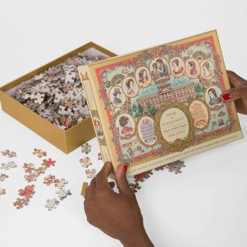
Tallis's Illustrated Plan of London and its Environs stands as an exquisite and very detailed victorian map of London, showcasing the magnificence of the United Kingdom’s capital.
Crafted by the skilled hands of John Rapkin and brought to life through the renowned English cartographic publisher John Tallis, this map is a testament to precision and elegance.
Encompassing the heart of London are 48 city views, each extending from Hammersmith in the west to the landscapes of Cricklewood, Hampstead, Stamford Hill, Leytonstone, Greenwich, Peckham, Battersea Rise, and Parson’s Green, creating a visual symphony of urban charm.
The myriad of colors serves as a vivid palette, delineating borough boundaries, roads, streets, city blocks, buildings, landmarks, parks, and various places of interest.
This map celebrates London’s grandeur. Commissioned to mark the Great Exhibition of Industry of All Nations in 1851, hosted in the verdant Hyde Park and orchestrated by the visionary minds of Henry Cole and Prince Albert, consort to Queen Victoria. The opening day witnessed a gathering of over 2500 of the global elite, elevating it to one of the most pivotal events of the XIX Century.
Envío gratis a partir de 50 euros.
Guía digital de Londres de regalo a partir de 75 euros.
Tiempo de entrega a península 48-72h (días laborales).
365 días para cambios o devoluciones.
Escríbenos a hola@superbritanico.com si necesitas ayuda.
![]()
25,95 €
24,95 €
Comprar 
21,95 €
Comprar 24,95 €
Comprar 
Mi tienda favorita. Es en la único en la que me permito darme caprichos. Regalos para mis amigas, familia y para mí. Este verano he paseado por isla mágica y por Extremadura mi gorrita, mi armario solo tiene sus camisetas y sudaderas, mi casa tiene mogollón de material de oficina de ellos. Por no hablar de los gemelos más molones que se lucirán en mi...

Boutique super sympa, avec des objets britanniques originales et drôles !

Hace tiempo que sigo a la marca y tengo varias cosas. Pero en esta ocasión pedí unos pendientes de Mary Poppins y son preciosos. También tengo dos camisetas y la calidad de los bordados y la tela es muy buena. Sin duda repetiré porque cada poco sacan cosas nuevas

He ido varias veces a la tienda. Cada vez que voy hay cosas nuevas y me surgen nuevas “necesidades”. Todo está cuidado al detalle y las personas que os atenderán son muy atentas y amables. Una visita recomendable para asomaros a un trocito de la cultura británica en Sevilla.

hice pedido por la página web. la atención y el mimo con el que preparan los pedidos es increíble. recomiendo mucho

¡Hoy me ha llegado mi termo! Llevaba tiempo queriendo comprar algo, pero al final nunca lo hacía, pero he aprovechado un cumpleaños próximo y además del regalo me he comprado un termo que, aparte de precioso, se ve que es una pasada. Me encantaría subir las fotos del termo pero Google, “doesn’t have the p… for little lanterns”, y no me deja subirlo…....

En pleno centro de Sevilla y frente al Palacio de Dueñas se encuentra una joya en forma de tienda. Al cruzar la puerta de Superbritánico es como si te trasladases a la propia Inglaterra. Ediciones preciosas de libros en inglés, ropa de gran calidad con bordados maravillosos que hacen referencia a obras, películas o personajes muy "british" y muchas cosas...

Un lugar de ensueño. Magnífico lugar para trasladarte a Londres desde el corazón de Sevilla, endulzado siempre con una taza de té.Muy recomendable.Saludos desde el corazón de Sanlúcar.

Increíble la amabilidad, una pequeña librería con un encanto Increíble.

Llevaba desde que empecé a estudiar Filología Inglesa queriendo ir. El sitio es super acogedor, te tratan genial. Quien me ha atendido tenía la voz más dulce que he escuchado. Los productos son ideales. Yo me he llevado una taza, una vela, un estampador de sellos, un mapa literario, y como no, un libro (entre otras más cosas). De regalo me han dado una...

Me gusta mucho la tienda, y tiene cosas muy curiosas y únicas. Sin embargo, veo dos pegas: La primera es que no tiene lista de deseos o favoritos en la web, y es un engorro tener que dejar fuera de la cesta (pero tener vigilado) todo lo que quieres comprar. La segunda, y más importante, es que reparten con MRW, y son nefastos. Envío dentro de la...

El pedido me llegó super rápido, y todo en perfecto estado. Repetiré seguro, y espero conocer la tienda física pronto.

Soy fan de vuestros productos desde hace tiempo y desde que abristeis la tienda siempre he tenido muchas ganas de ir. En este último viaje a Sevilla por fin he podido acercarme, es una preciosidad!! Gracias por todo lo que haceis

Superbritánico es una tienda maravillosa en el corazón de Sevilla que permite a los fans de la cultura británica que nos sintamos un poco más cerca de nuestra querida isla. Los productos son fantásticos, originales y de muy buena calidad. Todos los detalles están medidos, tanto en sus productos como en su tienda. El trato, la personalización y la...

Me encanta vuestra tienda, tiene cosas de buenísima calidad y es súper original. Ideal para los amantes de la cultura británica!

Puede que sea una de las tiendas más bonitas de Sevilla, está puesta con un gusto exquisito y además lo que venden es justo lo que "necesito". Son súper amables y detallistas. Si online funcionan de lujo, ir a verlas es maravilloso. Mi lado británico se queda recompensado.

Llevo siguiendo la marca desde sus comienzos y desde el minuto 1 han destacado por su cercanía con el público que les sigue, la calidad de sus productos y la originalidad de ellos, así como la poca producción de los mismos, cosa que me encanta ❤️🥰 Cuando empezaron con las obras de la tienda tenía claro que en cuanto pudiera escaparme a Sevilla sería una...

Son fantásticos!!! Desde la calidad de los productos a la atención dispensada. 100% recomendable!!!

Esta tienda es el paraíso para todo aquel amante de la cultura inglesa. Ya hace años que he adquirido algunos de sus productos a través de su tienda online, pero la física es un must para todo aquel que pasee por el centro de Sevilla. La decoración es insuperable, junto al cariño y detalle con que todo está expuesto por la tienda.

Tienda preciosa, trato exquisito, productos para enamorarse, lo tiene todo… imposible no ser fan de ellos ❤️❤️❤️